~ |
Online free nautical charts and publications
open data/open access - libre accès
Cartes marines gratuites et ouvrages nautiques en ligne
 | Home |


| B | 
| ||
A
Argentina/Argentine
Australia/Australie
About Nautical Free
Nautical Free provides a list of free nautical charts and online publications.There is a list by country from letter A to letter V, for each country the organizations and for each organization a list of free online documents (charts, nautical books, notice to mariners...). There is two special lists: one for the international organizations and one for the private companies. There is also a reverse list by type of documents: sailing directions, radio signals, tide tables, nautical charts... You can also find on Nautical Free wave forecast maps for tomorrow, space weather forecast for GPS, how to check your computer clock, as well as information about celestial navigation or about ice navigation...
Au sujet de Nautical Free
Nautical Free fournit une liste de cartes marines gratuites et d'ouvrages nautiques en ligne.Il y a une liste par pays de la lettre A à la lettre V, pour chaque pays les organisations et pour chaque organisation une liste de documents libres en ligne (cartes marines, ouvrages nautiques, avis aux navigateurs...). Il existe deux listes spéciales : une pour les organisations internationales et une pour les sociétés privées. Il existe également une liste inverse par type de documents : instructions nautiques, ouvrages de radiosignaux, tables des marées, cartes marines... Vous trouverez également sur Nautical Free des cartes de prévision de la hauteur des vagues pour demain, des prévisions de la météo de l'espace pour les GPS, comment vérifier l'heure de son ordinateur, ainsi que des informations sur la navigation astronomique ou la navigation dans les glaces...
Advice / Conseils
For navigation use only updated regulatory documents /
Pour la navigation n'utiliser que des documents réglementaires à jour.
GPS is more accurate than nautical charts /
Un GPS est plus précis qu'un carte marine
Web Servers / Serveurs Web
You can use the nearest or faster server / Vous pouvez utiliser le serveur le plus proche ou le plus rapide :
- French mirror with one page by section / Serveur en France avec une page par section : http://nauticalfree.free.fr
- French mirror on one page / Serveur en France sur une page : http://nauticalfree.free.fr/onepage.html
- French mirror without image on one page / Serveur en France sans image sur une page : http://nauticalfree.free.fr/noimage/
- US mirror with one page by section / Serveur au États-Unis avec une page par section : http://nauticalfree.eu5.org
- US mirror on one page / Serveur au États-Unis sur une page : http://nauticalfree.eu5.org/onepage.html
- US mirror without image on one page / Serveur au États-Unis sans image sur une page : http://nauticalfree.eu5.org/noimage/
- US mirror on seven pages / Serveur au États-Unis sur sept pages : https://sites.google.com/site/nauticalfree/
Caption / Légende
- The nautical books are in standard fonts / Les ouvrages sont en caractères droits
- In Italic the maps and the charts / Les cartes sont en italiques
- The last item for an organization is the Notices to Mariners. The first issue of each year is often a special publication /
La dernier item pour un service hydrographique est un lien vers les avis au navigateurs. Le premier numéro de chaque année est souvent un numéro spécial
- Raster Navigational Charts (RNC)
- Bitmap electronic images of paper charts that conform to IHO standard S-61 /
Carte marine matricielle, fac-similé numérique d'une carte papier (scan) conforme à la norme de l'OHI S-61 - Electronic Navigational Charts (ENC)
- Vector charts that conform to IHO standard S-57 /
Carte électronique de navigation, carte vectorielle conforme à la norme de l'OHI S-57
|
|
I - List by countries and organizations / Liste par pays et organismes
Cartes marines gratuites et ouvrages nautiques en ligne : Argentine et Australie
A
Argentina / Argentine
Servicio de Hidrografía Naval (SHN)
- Catálogo de Cartas y Publicaciones Náuticas (H-223)
Este catálogo contiene la información básica sobre las Cartas y Publicaciones que edita el Servicio de Hidrografía Naval. También:
- Publicaciones náuticas y técnicas
- Cartas Náuticas : Papel, especiales, ENC
- Buscador de Cartas Náuticas
- Geoportal - ENC para Argentina
View online charts (ENC) / Cartes marines consultables en ligne (CEN)
Not for navigational use / Ne pas utilisez pour la navigation
Geoportal para Agentina con Cartas de Navegación Electrónicas (CNE-ENC) y también Ayudas a la Navegación, Faros, Boyas y Balizas, Estaciones AIS AtoN, Zonas NAVTEX, Límites Láminas ENC, Límites Cartas Papel, Radioavisos vigentes (Navarea VI, Navtex, Rio de la Plata, Rios)... - Sistema de Balizamiento Marítimo y otras Ayudas a la Navegación
Índice: Antecedentes históricos - Principios generales del sistema - Reglas - Mapa de las regiones A y B. Se podrá bajar gratuitamente en formato PDF completando un formulario.
- Reglamento Internacional para Prevenir los Abordajes (H-224)
- Faros Argentinos
Según la definición del Diccionario del Bureau Hidrográfico Internacional, faro es "una estructura distintiva sobre una costa o alejada de la misma que presenta una luz principal destinada a servir de ayuda a la navegación". Más precisamente, una construcción costera que posee una señal luminosa característica cuya función es orientar al navegante. Generalmente ubicado en puntos destacados del litoral, en lugares altos, notables, ya sea artificiales o naturales. De su elevación dependerá el alcance que se quiera dar a la luz. En este sitio se actualizan las características nocturna y diurna de los faros permanentemente ya que afectan la Seguridad Náutica. No obstante, los navegantes deberán consultar las publicaciones reglamentarias Faros y Señales Marítimas, los Avisos a los Navegantes y Radioavisos Náuticos respecto a este tema.
- Formulario de Tablas de Marea (H-610)
En el formulario de tablas de marea (datos en HTML) se publican las horas y alturas de las pleamares y bajamares para los puertos. El SHN adoptó, desde 2004, la Bajamar Astronómica más Baja (LAT) como plano de reducción de sondajes. Índice: Tablas de Marea (Puertos del Río de la Plata y Litoral Marítmo Argentino Sudamericano, Suplemento Litoral Marítimo Argentino Antártico y Subantártico, Puertos secundarios), Tablas de Conversión, Tabla de Interpolación, Glosario de términos usados, Generalidades.
- Pronóstico Mareológico para el Río de la Plata: La Plata, Buenos Aires, San Fernando e Isla Martín García
- Alturas Horarias de Marea de los mareógrafos
- Litoral Marítimo Argentino Antártico y Subantártico
- Tablas de Predicción de la Corriente de Marea
Se suministra las predicciones de corrientes en 27 puntos del litoral marítimo, la información brindada corresponde a los instantes predichos de ocurrencia de la estoa y de la máxima corriente. Para este último caso se da asimismo la intensidad de la corriente expresada en nudos (1 nudo = 1 milla náutica/hora) y la dirección en grados respecto al norte geográfico y con sentido de rotación hacia el este. Debe aclararse que la predicción incluye la corriente permanente, no así el efecto meteorológico sobre la corriente de marea. Es de notar que en algunas estaciones se predice la ocurrencia de dos máximos de corriente consecutivos. La causa estriba en que el mínimo de corriente ausente tiene un valor de intensidad que no puede considerarse como estoa.
- Servicio de Hielo por la Antártida
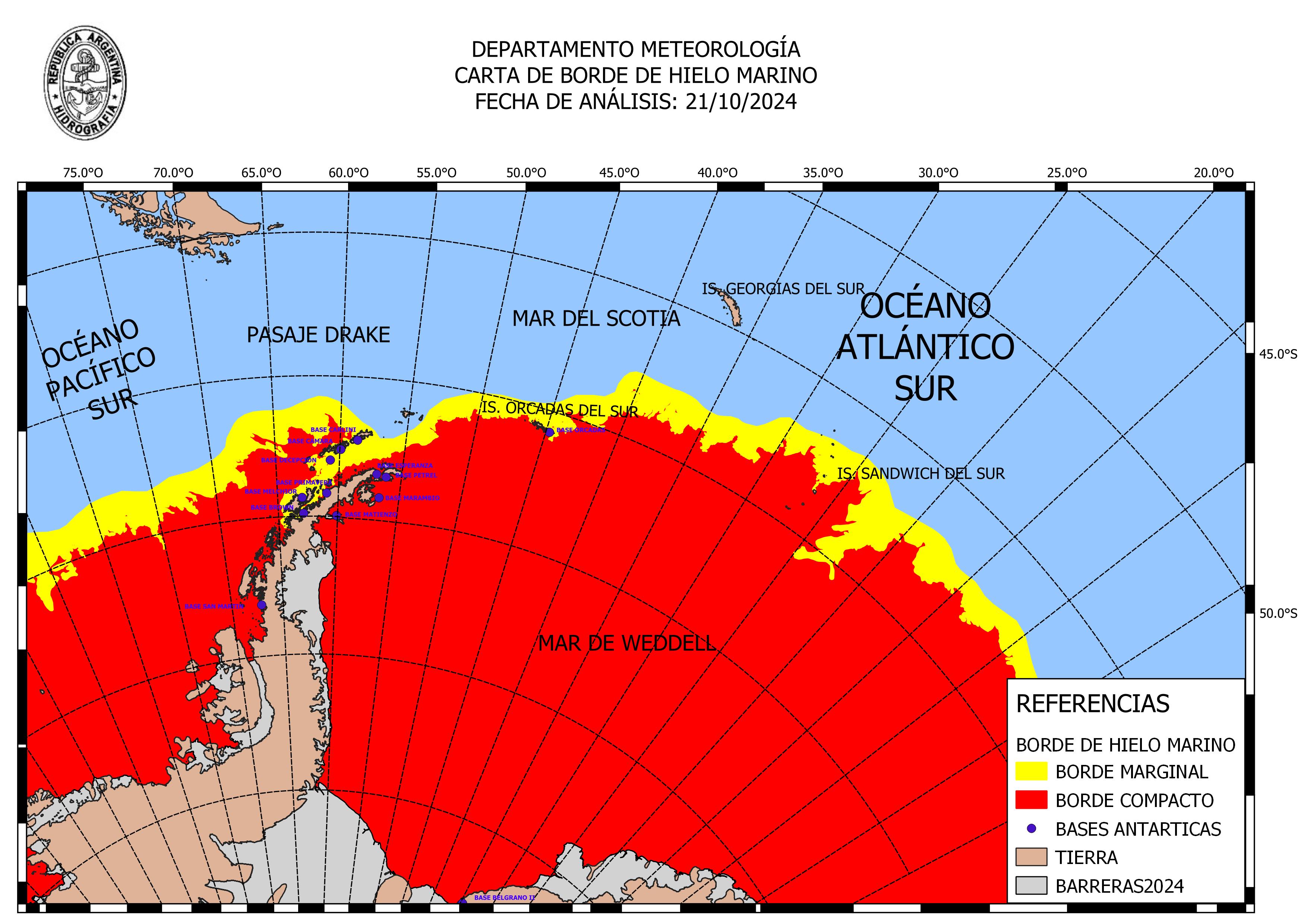
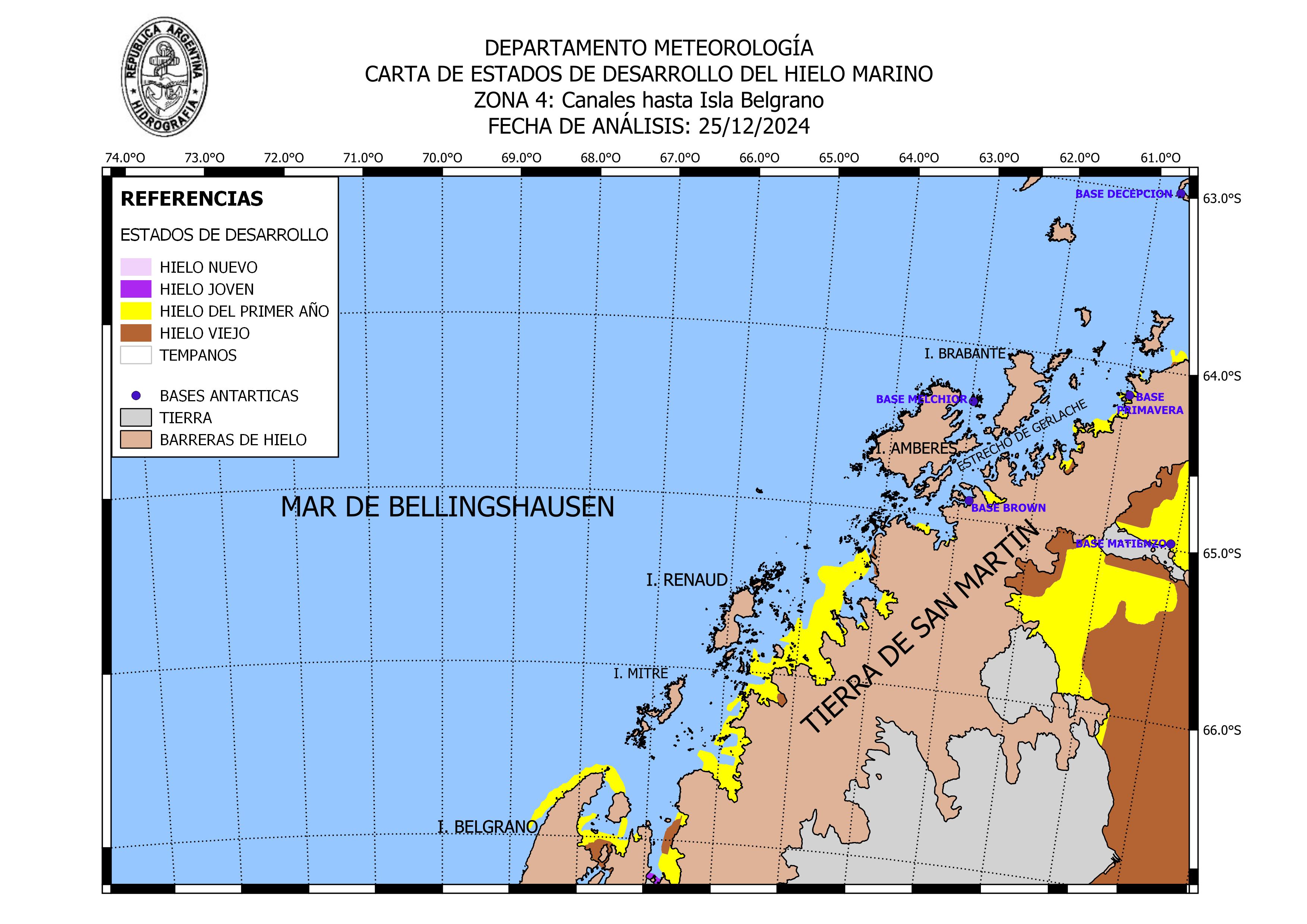
La información otorgada a través de las Cartas de Hielo es producto del análisis e interpretación visual de imágenes satelitales de alta resolución. Las Cartas de Hielo sintetizan las condiciones generales de hielo marino y témpanos para la fecha indicada en la correspondiente Carta, por lo que las condiciones descriptas pueden variar en función de cambios en la situación meteorológica imperante y debido a las corrientes marinas. La codificación de colores y nomenclatura empleada para la confección de Cartas de Hielo y registro de observaciones glaciológicas corresponde a los estándares de la Organización Meteorológica Mundial,
- Cartas de Hielo: Borde de Hielo Marino - Carta de Témpanos - Pronósticos de Concentración de Hielo Marino
- Cartas de Concentración de Hielo Marino: Pasaje Drake- Islas Orcadas del Sur y adyacencias - Mar de la Flota e islas Shetland del Sur - Canales hasta Isla Belgrano - Bellingshausen y Bahía Margarita - Estrecho Antarctic y Golfo Erebus y Terror - Weddell general - Weddell NW - Weddell Sur
- Observaciones de Hielo: Observaciones parte semanal - Registros
- Publicaciones: Manual del Observador de Hielo Marino y Témpanos - Hielo flotante en el mar (mural)
- Manual del Observador del Hielo Marino y Témpanos (H-419)
Se ha desarrollado el presente Manual a fin de servir como fuente de consulta y guía al momento de realizar las observaciones glaciológicas, tanto desde un buque como desde una base antártica. El correcto uso de la terminología, así como las explicaciones que encontrarán en este Manual, le permitirán al usuario realizar las observaciones según estándares internacionales con la posibilidad de generar los mensajes codificados IILL e IISS, que contienen el detalle de la información registrada. Así mismo, la transmisión de estos mensajes con información glaciológica permitirá a la División Glaciología del Departamento Meteorología del SERVICIO DE HIDROGRAFÍA NAVAL, el control de calidad de la información, la verificación del procesamiento de imágenes satelitales de alta resolución y la generación de más y mejores productos que sirvan para el asesoramiento glaciológico y de apoyo en la toma de decisión a los Comandantes y Autoridades en el planeamiento y/o ejecución de las actividades antárticas.
- Suplemento al Almanaque Náutico y Aeronáutico (Supl.H-225)
Sol, planetas y estrellas. Publicación que contiene datos sobre las posiciones aparentes de 324 estrellas fundamentales brillantes cada diez días, las efemérides del Sol, la Luna y cuatro planetas, el tiempo sidéreo a 0h TU y la ecuación del tiempo, junto a tablas que corrigen las observaciones y factores de conversión que agilizan los cálculos, contiene los datos necesarios para determinar la posiciȯn geográfica mediante observaciones astronómicas. Se complementa con un calendario, eclipses de Sol y de Luna, fases lunares, equinoccios y solsticios.
- Astronomía
Índice: Generalidades - Salida y Puesta de Sol - Salida y Puesta de Luna - Fases de la Luna - Eclipses - Equinoccios y Solsticios.
- Efemérides
Este programa provee: Salida, puesta, crepúsculo civil, náutico y astronómico del Sol, salida y puesta de la Luna y de planetas para cualquier punto de longitud conocida y para latitudes de hasta ±80° - Además calcula otros datos astronómicos como ser, ángulo horario y declinación, azimut y altura, refracción, paralaje horizontal, paso por el meridiano, etc., para Planetas, Sol y Luna. Fases de la Luna e información técnica. Tiempo de Sidéreo local y ángulo horario de Aries - Permite calcular hasta 365 datos, guardarlos en un archivo e imprimirlos (Windows).
- Hora Oficial y Frecuencia Patrón
Información sobre señales horarias: Señales Horarias generadas por el Observatorio Naval Buenos Aires -Cuadro comparativo de algunas Señales Horarias - Husos Horarios adoptados en la República Argentina - Hora Oficial en diferentes lugares del mundo - Hora Oficial Argentina
Pronóstico Numérico de Olas sobre el Atlántico Sur para mañana - Alturas en metros Pronóstico Numérico de Olas sobre los Oceanos Australes para mañana - Alturas en metros - Wave Model for the Southern Oceans and South Atlantic
Hourly fields of 6 hours of retroanalysis and 96 hours of wave forecast, corresponding to the most recent forecast hour. The forecast hours are 00 Z, 06 Z, 12 Z and 18 Z and the products are estimated to be available at H + 4.5 hours. All heights are expressed in meters. The significant height is inferred in the model from the total energy of the waves. It resembles the characteristic height that an experienced observer visually estimates in a wave field and is the most widely used proxy measure of the field. However, it should be noted that individual waves can exceed significant height (ideally just over 13% of the waves) and even under normal conditions, an individual wave could double this height. The peak direction is the mean direction at the frequencies containing the maximum energy and is, in general, close to the direction of the maximum. The period of the energy peak or dominant period is the one corresponding to the frequencies that contain the maximum energy.
- Pronóstico Numérico de Olas (SMN)
La altura significativa se infiere en el modelo a partir de la energía total de las olas. Se asemeja a la altura característica que un observador experimentado estima visualmente en un campo de olas y es la medida representativa del campo más utilizada. Sin embargo, se debe destacar que las olas individuales pueden exceder la altura significativa (idealmente algo más del 13 % de las olas) y aun en condiciones normales, alguna ola individual podría duplicar esta altura. La dirección del pico es la dirección media en las frecuencias que contienen la máxima energía y es cercana, en general, a la dirección del máximo. El período del pico de energía o período dominante es el correspondiente a las frecuencias que contienen la máxima energía. Todas las alturas se expresan en metros.
- Oceanos Australes: Altura significativa - Pronóstico de olas para mañana
- Oceano Atlántico: Altura significativa - Altura de olas de mar de viento
- Descargas: Publicaciones náuticas y programas
Descargar publicaciones náuticas y programas: Almanaque Náutico y Aeronáutico - Efemérides - Libro de Faros Digital - Límite Exterior de la Zona Económica Exclusiva de la República Argentina - Reglamento Internacional para Prevenir los Abordajes - Sistema de Información Glaciológica SIGLAC-C V1.1.0 - Sistema de Balizamiento Marítimo...
- Radioavisos Geoportal
Geoportal con los avisos vigentes para Argentina: NAVAREA VI - NAVTEX Ushuaia - NAVTEX Rio Gallegos - NAVTEX Comodoro Rivadavia - NAVTEX Bahia Blanca - NAVTEX Mar del Plata - NAVTEX Buenos Aires - Riopla - Rios. Este geoportal no reemplaza los canales oficiales de comunicacion navtex y safetynet. Limites internacionales y espacios maritimos aproximados. No apto para navegar.
- Radioavisos náuticos / Radionavigational Warnings
Este Sitio se actualiza permanentemente con los acontecimientos que afectan a la seguridad náutica, no obstante se recomienda a los navegantes utilizar la difusión de los radioavisos náuticos a través de los diferentes canales de comunicación radial o satelital. Índice:
- Boletín Avisos a los Navegantes (H-216 y H-217)
El Servicio de Hidrografía Naval (SHN) presta el Servicio Público de Seguridad Náutica editando la publicación H-216 "Avisos a los Navegantes" y la publicación H-217 "Avisos a los Navegantes - Hidrovía Paraguay-Paraná". La Sección I contiene los avisos a los navegantes con las modificaciones a ser incorporadas por los mismos en todas las versiones (soportes) de las Cartas Náuticas (Papel y Electrónicas / S-57), Croquis de los Ríos, Derroteros Náuticos, Listas de Faros y Señales Marítimas, Radioayudas para la Navegación y demás publicaciones náuticas editadas por este servicio. Se edita con el mismo formato, la Publicación H-217 "Avisos a los Navegantes - Hidrovía Paraguay-Paraná" con las novedades exclusivas para dicha vía navegable (Más informaciónes).
- Catálogo de Cartas y Publicaciones Náuticas (H-223)

Australia / Australie
- Australian Hydrographic Office (AHO)
- Australian Maritime Safety Authority (AMSA)
- Australian state and territory marine authorities
- Bureau of Meteorology (BoM)
- Australian Maritime College (AMC)
- Australasian Legal Information Institute (AustLII)
Australian Hydrographic Office (AHO)
- Catalogue of Australian Charts and Publications
- Tidal & Nautical Publications
- Charts: Chart Index (text-based format) - Chart Index Application (graphical interface)
- Australia: : Aus Paper Chart List - AU ENC Cell List
- Papua New Guinea: PNG Paper Chart List - Index of Paper Nautical Charts (PNG 2000) - Index of Electronic Navigational Charts (PNG 2001)
- Solomon Islands: SB Paper Chart List - Index of Paper Nautical Charts (SLB 1001) - Index of Electronic Navigational Charts (SLB 1002)
- Pricing and Fees - Distribution Agents
- Mariner's Handbook for Australian Waters (AHP20)
The Mariner’s Handbook for Australian Waters (AHP20) is an official nautical publication. This publication provides mariners with important regulatory, procedural and environmental information affecting the planning and conduct of a voyage to, or from, Australian ports, or within Australian waters. It includes a summary of all relevant information from various Australian government agencies under the cover of one combined reference, with links to further information if required. The publication includes: Major Australian maritime legislation and regulations - Marine Protected Areas - Coastal Pilotage arrangements - Torres Strait and Great Barrier Reef shipping routes, accident and incident reporting - Maritime Safety Information, meteorological broadcasts, Warnings, search and rescue - Ship Reporting Systems: AUSREP and REEFVTS - Maritime security - Pilots, boarding arrangements, arrival and departure notification requirements, VHF Channels and port contact details - Mariners guide to interpreting the accuracy of depth information in Electronic Navigational Charts (ENC) - Important information relating to the accuracy of charts, Zones of Confidence (ZOCs) - Effects of over-scaling in Electronic Chart Display and Information Systems (ECDIS)... Download:
- Australian National Tide Tables (AHP11)
Australian National Tide Tables (ANTT) contains information for over 90 Primary and 700 Secondary ports in Australia, Papua New Guinea, Solomon Islands, Antarctica and Timor-Leste. This information includes: Predictions for high and low water for each day of the year for all Standard Ports - Tidal level and time differences for all Secondary Ports - Instructions and forms for calculating intermediate times and heights - Effects of wind and barometric pressure on tide, particularly at certain ports - Details of transmitting tide gauges in Torres Strait - Predictions of maximum rates of tidal streams for Torres Strait and Port Phillip Heads - Tidal Stream diagrams for Sydney, Broome and Darwin. Predictions in ANTT for times and heights for high and low water are referenced to Lowest Astronomical Tide (LAT). Download:
- Australian Tide Tables 2024 (pdf)
- Papua New Guinea Tide Tables (pdf)
- Solomon Islands Tide Tables 2024 (pdf)
- Timor Leste Tide Tables 2024 (pdf)
- AusTides (AHP114)
AusTides is an official electronic product (software) that is equivalent to paper Australian National Tide Tables (ANTTs). AusTides contains information for over 80 Primary and 600 Secondary ports in Australia, Papua New Guinea, Solomon Islands, Antarctica and Timor-Leste. Most importantly, the additional functionality within AusTides replaces any requirement to manually calculate intermediate times and heights for port entry and departure. AusTides includes: Predictions for high and low water for each day of the year for all Standard and Secondary Ports - Interactive tidal curves allowing identification of tidal windows when tides of sufficient height are available - Predictions at each port location presented graphically at 10, 20, 30 and 60 minute intervals - Predictions of maximum rates with graphical curve of tidal streams for Torres Strait and Port Phillip Heads - Tidal Stream diagrams for Sydney, Broome and Darwin - List of the main 22 harmonic constituents for all Standard and Secondary Ports. Predictions in AusTides for times and heights for high and low water are referenced to Lowest Astronomical Tide (LAT). AusTides is compatible with Windows 10, MacOS Intel, MacOS RISC/ARM and LINUX OS. Download:
- Tidal information web service
ANTT tidal information is also be available via an interactive web service on the AHO website. This platform provide an enhanced user experience by giving access to tidal information in an intuitive and functional way, via a searchable map allowing specific port discovery with the ability to view and download individual port tidal data. Time Zones of predictions are those of the official Standard Time kept at the location. All predicted heights are given in metres above Lowest Astronomical Tide (LAT).
- Tidal Glossary
Terms that are often used in Tidal Science.
- AHO Fact Sheets: ENC, navigation, paper charts
AHO Fact Sheets provide answers to the AHO’s most frequently asked questions. They provide a ready reference for mariners, provide links to sources of more information, and are a starting point for those providing instruction to mariners. Fact sheets: AusENC Frequently Asked Questions - Official and Unofficial Electronic Charts - GPS Receivers and Chart Datums - Tides: Calculating HW and LW at Secondary Ports - Accuracy and Reliability of Paper Nautical Charts - Understanding Paper Nautical Chart Symbology - Updating Paper Nautical Charts...
- Australian Chart and Publication Maintenance Handbook (AHP24)
The Australian Chart and Publication Maintenance Handbook providesinformation to assist mariners to keep paper and electronic nautical charts and publications up to date, as well as to keep appropriate maintenance records. By using this book, mariners should be able to meet their obligations under both national and international maritime legislation and the more specific inspection requirements imposed by safety and regulatory authorities. Download:
- Maintenance Handbook, 5th Edition, 2025 (AHP24)
- Chart Correction Log (CCL, AHP24 part2)
- Accuracy and reliability of Paper Nautical Charts
How accurate are nautical charts? How much faith can be placed in them? Unfortunately, the answer is quite complex – far more complex than simply saying one chart is accurate whilst another is not. However, having the necessary skills should be essential for any mariner venturing into unfamiliar waters. All charts, whether paper or electronic, contain data which varies in quality due to the age and accuracy of individual surveys. In general, remote areas away from shipping routes tend to be less well surveyed, and less frequently, while areas of high commercial traffic are re-surveyed frequently to very high levels of accuracy, particularly where under-keel clearances are small. It is quite accurate to consider a chart as a jigsaw of individual surveys pieced together to form a single image.
- Facts about Electronic Charts and Carriage Requirements
Written in an easy to read “question and answer” style, this publication answers over twenty of the most commonly asked questions about electronic charts (ENCs and RNCs) and their use in ECDIS and ECS. Its main emphasis is on what types of chart data and types of equipment can be used to satisfy the International Convention on the Safety of Life at Sea (SOLAS) carriage requirements for charts (IHO, S-66, 2018).
- Understanding Paper Nautical Chart Symbology
At first glance, a chart looks simple to interpret. However, what exactly do all those different symbols mean? Before your next day on the water, have a look at the symbols taken from a few Australian Paper Nautical Charts.
- Use of Paper Charts in Australian Waters Explained
Paper Charting Information. Frequently asked questions about paper charts in Autralia.
- Use of Electronic Charts in Australian Waters Explained
The electronic chart carriage rules and regulations in Australian waters. For a comprehensive overview about electronic charts (ENC and RNC), electronic charting systems (ECDIS and ECS) and electronic chart carriage requirements under the International Convention on the Safety of Life at Sea (SOLAS), we recommend you read this page.
- ENC Viewer - Australian Chart Index Application
View online Electronic Navigational Charts (ENC) / Cartes marines vectorielles consulable en ligne
Not for navigational use / Ne pas utilisez pour la navigation
The AHO has released a new web service to facilitate the discovery of our charting products (paper charts and ENC) in an easy to use graphical interface that has the option to display our ENC content around Austrlia as background. For ENC click on the four windows icon and then click on "AHO ENC Series Basemap" icon. The data contained in this service is provided for information and product discovery purposes only and must not be used for navigation and decisions for this purpose must not be made using the data presented in this service. - Australian ENC Sample Cell
Electronic Navigational Charts for upload (ENC) / Cartes marines vectorielles téléchargables
Not for navigational use / Ne pas utilisez pour la navigation
A free, unprotected ENC data cell, covering an area of the NSW coast (including Yamba and the Solitary Islands), is available for download and evaluation, for users unfamiliar with ENC. This cell may be viewed using AusChartviewer, or one of many navigation systems capable of using ENC. - Astronomical Definitions
Definitions for common astronomical terms (Geoscience Australia).
- Compute Sunrise, Transit, Sunset and Twilight Times
The transit time of a celestial body refers to the instant that its center crosses an imaginary line in the sky - the observer's meridian. It's represents the time at which the body is highest in the sky on any given day: the transit of the Sun is local solar (sundial) noon. At the twilight time in the absence of moonlight, artificial lighting or adverse atmospheric conditions, the illumination is such that large objects may be seen but no detail is discernible. The brightest stars and planets can be seen and for navigation purposes at sea, the sea horizon is clearly defined (Geoscience Australia).
- Maritime Gazetteer of Australia
The Maritime Gazetteer of Australia (MGA) is a searchable database containing all the place names used in Australia's official navigational charts.
- Product Downloads
Official Nautical Publication Downloads. Publication downloads incorporate the latest applicable Notice to Mariners update. Users are encouraged to subscribe to eNotices to be notified by email when new updates are available for download. Content: Tides, Mariner's Hanbook, Chart and Publication Maintenance Handbook, AusChartviewer, ENC Sample Data-Cell...
- Australian Notices to Mariners (NTMs)
Australian Notices to Mariners are produced fortnightly to inform mariners of amendments of navigational significance to their chart portfolios. Notices to Mariners, tracings, blocks and other supplements are available in PDF format (More informations).

- Catalogue of Australian Charts and Publications
Australian Maritime Safety Authority (AMSA)
- Changes to EPIRB laws for domestic commercial vessels
An EPIRB is a critical piece of safety equipment for crew and passengers on sinking or capsized vessels, in a fire, collision or vessel grounding. From 1 January 2021, new laws covering the carriage of emergency position indicating radio beacons (EPIRBs) will apply to certain types of domestic commercial vessels (DCV). The type of EPIRB you need depends on vessel class, length, flotation and operating area.
- Depiction of charted information—electronic navigation chart vs paper chart
This Pilot Advisory Note (2/2020) informs about circumstances where the information depicted on an ENC may differ to the information on a paper chart for the same location. Note that in all cases where a difference may be noted: 1) The ENC depiction will more closely resemble real-world features due to scale limitations inherent in paper charts; 2) ENC are used as the source for updating paper charts – updates to paper charts will therefore either be released in parallel with the ENC, or lag behind, but will never precede an ENC update.
-
This marine notice (8/2021) draws attention to important information regarding the proper operation of Electronic Chart Display and Information Systems (ECDIS), including the importance of adequate and up to date Electronic Navigational Charts (ENCs), for ships visiting Australian ports.
- Vessel traffic services (VTS) areas in Australia
Vessel traffic services (VTS) assist domestic and international vessels to avoid dangerous situations in our region. There are currently 15 authorised vessel traffic services in Australia including REEFVTS (Great Barrier Reef and Torres Strait Vessel Traffic Services). Here is a list of VTS areas in Autralia with specific information.
- Great Barrier Reef and Torres Strait Vessel Traffic Service (Reef VTS) – User Guide
The environmental and cultural significance of the Great Barrier Reef and Torres Strait regions are internationally recognised. In 1990 the International Maritime Organization (IMO) named these regions Particularly Sensitive Sea Area (PSSA). The Great Barrier Reef and Torres Strait Vessel Traffic Service (Reef VTS) was established in 2004 as a mechanism to improve the safety and efficiency of vessel movements and to help protect the marine environment. The purpose of the Reef VTS user guide is to assist masters of ships transiting the Reef VTS area on the services provided by Reef VTS (2021).
- Navigation through the Great Barrier Reef and Torres Strait
Knowledge of regulations and duties will help you navigate safely on the seas. The safety of shipping depends on you having detailed knowledge of, and complying with, regulatory and other obligations and duties we set out according to our legislation. This quick guide highlights your key obligations when transiting through the Great Barrier Reef and Torres Strait.
- Queensland Coastal Passage Plan (QCPP)
The Queensland coastal passage plan (QCPP) seeks to improve pre-pilotage communications between coastal pilotage providers, the vessels they service, and the appointed coastal pilots. The QCPP improves the readiness of ships transiting coastal pilotage areas within the Great Barrier Reef and Torres Strait by ensuring voyage plans, waypoints and other planning considerations have been completed in a standardised manner. See also: Passage Plan uniform waypoints.
- MASTREP: Modernised Australian Ship Tracking and Reporting System
The Modernised Australian Ship Tracking and Reporting System (MASTREP) is a ship reporting system designed to contribute to safety of life at sea. Participation in MASTREP is mandatory for certain vessels and others are encouraged to participate.
- About the AIS: automatic identification system
The AIS is a maritime communications device that improves navigation safety and environmental protection by assisting in the effective navigation of ships. See also: LRIT.
- About maritime mobile service identity (MMSI) information
Why you need a maritime mobile service identity (MMSI), and how to apply for one. We allocate maritime mobile service identity numbers (MMSI’s) to people who own a vessel or unit that has either: Digital selective calling (DSC) capable equipment - Automatic identification system (AIS) units.
- Distress Beacon and MMSI Information brochure
Frequently asked questions about distress beacon (EPIRB, PLB & ELT) and Maritime Mobile Service Identity (MMSI).
- Australian Global Maritime Distress and Safety System (GMDSS) Handbook
The Australian GMDSS Training and Operations Manual. This Handbook has been produced by the Australian Maritime Safety Authority (AMSA), and is intended or use on ships that are: 1) Compulsorily equipped with GMDSS radiocommunication installations in accordance with the requirements of the International Convention for the Safety of Life at Sea Convention 1974 (SOLAS) and Commonwealth or State Government marine legislation; or 2) Voluntarily equipped with GMDSS radiocommunication installations. It is the recommended textbook for candidates wishing to qualify for the Australian GMDSS General Operator’s Certificate of Proficiency.
- GMDSS radio log book
Marine Order 27 requires a radio log-book to be carried on board vessels subject to the Navigation Act 2012. The GMDSS Radio Log Book (the radio log) should be kept in a location close to the radio station. Pages from this form should be printed as required and kept as a hard-copy. The radio log, and associated records, must be kept onboard for at least 2 years. The radio log must contain a summary of communications relating to distress, urgency and safety messages. Details of commercial communications exchanged via GMDSS communications equipment may also be recorded in the radio log. The radio log should contain a record of important incidents connected with the radio service.
- Maritime ship licence (ACMA)
You need a maritime ship licence to use radio equipment on board a ship and you must be qualified to operate a maritime ship station.
- List of Registered Ships
Search for a registered ship on the Australian General and International Shipping Registers. You can search for a vessel using basic details about the ship. You can search either by the ship’s name, or the ship's official number for a more accurate search. The official number is the six digit number issued by the Shipping Registration Office to Australian registered ships. Other details such as the type of ship, overall length, or principal material of construction may be useful for searching purposes to check for matches in the register. See also: Search for Australian MMSI number.
- National Search and Rescue Manual
The National Search and Rescue Manual is the standard reference document for use by all search and rescue authorities and other organisations that provide search and rescue services in Australia. It outlines the agreed methods of coordination through which search and rescue operations are conducted within Australia. The manual is consistent with the relevant International Conventions to which Australia is party. The National SAR Manual includes material covering: a) Abbreviations, terminology and definitions relevant to SAR practitioners; b) The elements and functions of the Australian SAR system; c) Details of communications, assets and procedures for coordination; d) SAR planning and techniques including worksheets. The National Search and Rescue Manual acts as a set of procedures and guidelines in providing a search and rescue response within Australia.
- Increase productivity, reduce accidents
Seafarers are much more likely to die from injury at work.This brochure provides ideas about simple methods for managing the welfare of your crew.
- National Standard for Commercial Vessels
The National Standard for Commercial Vessels (NSCV) sets standards for vessel design, construction, equipment, operation and crew competencies for domestic commercial vessels. We maintain a list of current and superseded versions of the NSCV for your information.
- Fire safety (C4)
- Safety Equipment (C7A)
- Communications Equipment (C7B) - Navigation Equipment (C7C)
- Leisure Craft (F2)
- ...
- Marine Orders
Marine orders are regulations made under Commonwealth legislation. Marine orders contain the detailed requirements and processes ensuring legislation keeps up to date with technical and operational advances in maritime safety and environment protection. They also put international and national maritime standards into effect.
- Pilot Advisory Notices.
Pilot advisory notes provide guidance specific to coastal pilotage. These resources will provide you with details about under keel clearance requirements, shallow water alerts, incident reporting and reporting procedures, carriage of electronic charting systems, and more.
- Marine Notices
Marine notices provide important safety related information, general guidance and details about forthcoming changes to legislation to the shipping and maritime community. While marine notices have no legal standing, they provide important safety related information, general guidance, or details about forthcoming changes to legislation.
- Maritime Safety Information (MSI) database
Navigational maritime safety information (MSI) for NAVAREA X and Australian coastal areas is issued by the Joint Rescue Coordination Centre (JRCC) Australia. Navigational warnings are current for the time indicated and can be updated by refreshing the webpage. You can search our maritime safety information by selecting the search filter boxes and by sclicking on the search button to display the results. Type of messages: Safety Messages - NAVAREA X warnings - AUSCOAST Coastal warnings - Summary of Mobile Drilling Rigs - Special Purpose Vessels.
- Changes to EPIRB laws for domestic commercial vessels
Australian state and territory marine authorities
- New South Wales Maritime Services (NSW, Sydney)
- Northern Territory Department of Transport - Marine Safety Branch (NT, Darwin)
- Maritime Safety Queensland (QLD, Brisbane)
- Boating and marine South Australia (SA, Adelaide)
- MAST: Marine and Safety Tasmania (TAS, Hobart)
- Safe Transport Victoria - On the water (VIC, Melbourne)
- Western Australia Department of Transport (WA, Perth)
Boating and marine in New South Wales (NSW, Sydney)

- Boating Handbook: to understand the basic rules for safe and responsible boating in NSW (PDF & eBook formats)
- Maritime and nautical terms: From A to Z, with a diagrams of vessels
- Boat driving licence practical logbook
- Tide tables: for Sydney with time variations for NSW Ports and Rivers (PDF & eBook formats)
- Wave Wind Tide Current: for Botany Bay, Sydney Harbour, Eden
- Radio Network Services: VHF, HF and 27 MHz
- NSW Marine VHF Repeater Map: regional coverage with channels
- Boating Maps: regional and coastal pdf maps, not for navigational purposes
- Hydrographic Plans: Batemans Bay Bar, Clarence River ands Swansea Channel
- Boating plans for NSW waterways: Include handy hints for safe boating
- NSW lighthouses
- Maritime boat ramp locator: interactive map
- Mooring Maps: Sydney, Pittwater, Brisbane...
- Rules for boating on Sydney Harbour: here's what you need to know
- Sydney Harbour Master's Directions: for Sydney Harbour, Yamba, Newcastle, Botany, Kembla, Eden
- Sydney Harbour Boating Destinations Maps: facilities for recreational boaters
- Navigation in Sydney Cove: map with incoming and outgoing areas
- Sydney Harbour Superyacht Guidelines: for recreational vessels with an LOA of 30m or more
- Wharf access in Sydney Harbour: For commercial vessels
- Wharf list for Sydney Harbour: Charter & commuter wharves
- Wharf Map for Sydney Harbour
- Look Out Ships About: Saftey notice for Sydney Harbour & Botany Bay
- Sydney Harbour Boating Destinations Map: Identifying destination marinas
- Boating Destinations Plan Brochure: What to do when you arrive (2013)
- Boating Destinations Map: Find your closest destination with an interactive map
- Wave size, boat size and boating conditions: performance capabilities and limitations of a boat acccording to its size
- Identifying vessels at night
- Crossing coastal bars: how to prepare for a safe bar crossing
- Coastal bar safety booklet: What you need to know to safely cross a coastal bar (PDF file)
- Location of NWS Coastal bars: Lists & webcam
- Cold water and hypothermia
- When to wear a lifejacket: the most important safety equipment
- Boating safety publications
- Marine Notices: check it before you go boating
Northern Territory Department of Transport - Boating, fishing and marine (NT, Darwin)
- Safety guide for recreational boating: for pleasure craft
- Indigenous maritime safety guide: for recreational boating
- Recreational boat safety quiz: test your knowledge about boating safety
- Tidal predictions: for Northern Territory ports
- Find a boat ramp: includes an interactive maps
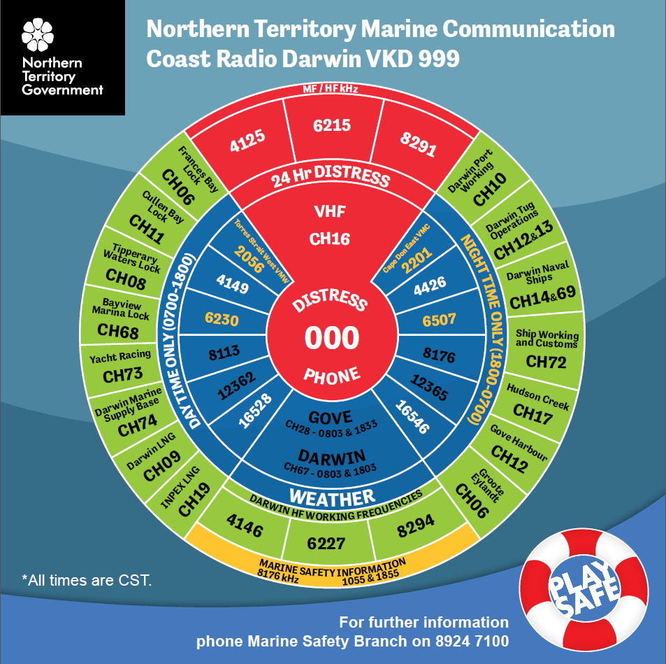
- Northern Territory Marine Communications: Coast Radio Darwin (VKD999) - VHF, MF & HF - Distress, weather, MSI & working frequencies
- Marine Safety Information: HF stations
- Darwin Port: Port Handbook - Pilotage - Passage Plan - Harbour VHF Communications - Cyclone Procedure
- Wharves and moorings in Frances Bay, Darwin
- Notice to mariners: Coastal Notices & Port of Darwin Local Notices
Maritime Safety Queensland (QLD, Brisbane)
- BoatSafe Workbook: to prepare the BoatSafe course
- Buoys, marks and beacons factsheet: information on different navigation marks and their meanings (PDF)
- Navigation—buoys, marks and beacons: IALA Buoyage System A and other navigational aids (HTML)
- Educational video: navigation lights, maritime and boating terms, Colregs...
- Queensland Tide Tables: standard port tide times
- Queensland supplementary tide predictions: more ports
- Tides - Notes and definitions
- Marine communications factsheet: equipment, operating procedures
- Marine radios: with key radio call procedures
- Ship navigation area warning: chartlet with recommended small craft course
- Gold Coast superyacht guide: from accessing navigation channels to the marine service sector’s capabilities
- Anchoring and Mooring in Gold Coast Waterways: map with restrictions
- Gold Coast Public boat ramps, jetties & pontoons: PDF maps
- Boating maps - Beacon to Beacon Guides: maps from the southern Gold Coast to Keppel Bay and Rockhampton, intended for recreational boating, should be used as a guide for navigation


- How to use the Beacon to Beacon Guides: including a legend
- Great Barrier Reef and Torres Strait Vessel Traffic Service
- Reef VTS User Guide: Great Barrier Reef and Torres Strait VTS (PDF)
- Pilotage areas: maps with description of the pilotage areas
- Passage plans for Queensland ports: pilotage plans and procedures
- Port procedures for Shipping Manuals: procedures to be followed in the pilotage area
- Port of Brisbane Facilitie: Operations manuals
- Mackay region - Standard for Commercial Marine Activities
- Townsville region - Standard for Commercial Marine Activities
- Boating safety in the Gladstone area
- Gladstone - Small craft ship navigation areas and recommended coursess
- Standard for Commercial Marine Activities - Gladstone Region: Including Gladstone, Port Alma, Bundaberg and Maryborough Pilotage Areas
- Port Procedures and Information for Shipping - Gladstone: information and guidelines to assist ship's masters in the pilotage area
- Port of Gladstone Information Handbook: detailed overview of the port’s facilities and service (GPC)
- Port of Rockhampton Information Handbook
- Port of Bundaberg Information Handbook
- Standard for Cruise Ship Navigation - Hervey Bay to Kingfisher Bay Resort: applies to all cruise ships over 50m LOA
- Marine Information Bulletins: important safety issues or regulatory requirements
- Notices to Mariners: marine safety information, charts corrections
Boating and marine South Australia (SA, Adelaide)
- South Australian Recreational Boating Safety Handbook: for the leisure and pleasure boatie
- Master Port rules: for Port Adelaide, Port Pirie, Port Lincoln...
- Pilot Passage Plans: pilotage information for Port Adelaide, Klein Point, Port Pirie...
- Boating Facilities
- Boat ramp interactive map: with launching conditions
- Jetty locations interactive map
- Marine radio: Distress frequencies (27 MHz, VHF and MF/HF), HF safety communications, MF/HF weather broadcasts (Charleville VMC and Wiluna VMW), HF navigational warnings (Adelaide, Melbourne and Perth)
- Volunteer Marine Rescue (VMR) Coastal Radio Network: 27MHz, VHF and MF/HF frequencies, coverage and location of VHF repeaters
- Carrying and wearing lifejackets
- Children's life jackets: Choosing a child's life jacket li>Which lifejacket do you need?: answer some quick questions to know before you go
- How to fit a lifejacket correctly: brochure to select the appropriate life jacket
- Notices to mariners: for South Australian waters including the River Murray
MAST: Marine and Safety Tasmania (TAS, Hobart)
- Safe Boating Handbook: Boating safety information and Tasmania’s boating rules
- Navigation Rules, Marks & Lights: Rules of the road at sea
- Operational Areas: Determine the safety equipment to be carried on board
- Cruising Tasmania: Information for recreational vessels
- Boating Guides: transit times, safe anchorages, facilities
- Tasmania Sailing Guide: HTML, by Jack and Jude (2020)
- Marine Facilities: Boat ramps, jetties & wharves, marinas, public cruising moorings
- Location of Moorings: Web mapping system for Tasmania
- Nautical Chart: For ENC Navionics click on "Nautical Chart"
- Tasmanian Port Information: Bell Bay, Brunie, Devonport, Hobart (Tasports)
- Tasmanian Vessel Traffic Services: VTS communications (Tasports)
- Tasmanian Port Charges (Tasports)
- Tasmanian Marine Services: Pilotage & Towage(Tasports)
- Trip Preparation: Preparation before heading out
- VHF radio in Tasmania: Guide to operating a VHF marine radio
- Marine VHF Repeater Network: Map with repeaters and channels
- HF Marine Communications in Tasmania: Distress and safety, MSI broadcasts
- Tas Maritime Radio (TMR): MSI Schedules and Frequencies - Also pdf file
- Marine Safety Guides & Tips: Videos like Man overboard, Flares and how to use them...
- Cold Water Immersion: video
- Notices to mariners
Safe Transport Victoria - On the water (VIC, Melbourne)
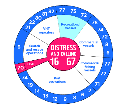
VHF marine radio channels- Changes to Marine Regulations: Apply from June 11, 2023
- Victorian Recreational Boating Safety Handbook: Guidance and safety information (PDF)
- Recreational Boating: Advice on how to handle boats and navigate waterways (HTML)
- Waterway maps: Local vessel operating and zoning rules for Victorian waterways, not to be used for navigational purposes
- Boating Guides for Gippsland area: Anderson Inlet - Gippsland Lakes - Lake Tyers - Mallacoota
- Waterways Online for Gippsland area: Web maps include Vessel Operating and Zoning Regulations, aids to navigations, berth and mooring location...
- Boating Facilities for Gippsland area: Anderson Inlet - Corner Inlet and Port Albert - Gippsland Lakes - Mallacoota - Snowy River (Marlo) - Lake Tyers - Shallow Inlet
- Notice to Mariners & Warnings for Gippsland area: Local Navigation Warnings (LNW’s)
- Waterways: Rules and exclusion zones: Rules for all waterways in Victoria
- Buoyage system: To guide through navigable channels, warn of hazards, and indicate safe water
- Steering and sailing rules: COLREGs, the rules of safe navigation
- Harbour Master’s Directions: Ports of Melbourne, Geelong & Hastings
- Victorian harbour master's Directions
- Tide Gauges for Geelong channels: Corio Bay and Port of Hastings
- Marine radio: VHF & HF
- VHF marine radio channels: 27MHz radios no longer meet the definition of marine radios
- Flares : For recreational vessels
- Wear a lifejacket : What lifejacket am I required to wear
- Safety equipment: Carrying the right safety equipment and knowing how to use
- What to do in an emergency: Call triple zero (000) if you are involved in or witness an emergency
- Notices to mariners (TSA): Advice on general navigation and safety issues
- Notices to mariners (VCRA)
Western Australia Department of Transport (WA, Perth)
- Recreational Skipper’s Ticket Workbook: all the material that you will need to know to gain an RST, with quizzes
- Download nautical charts and chart corrections: Bremer Bay to Esperance, Cape Peron to Albany, Carnarvon to Shoal Point, Exmouth to Coral Bay, Gregory to Perth, Lake Argyle
- Boating guides: provide local marine safety information, with maps
- Western Australian Cruising Guide: pilot by the Fremantle Sailing Club
- Fremantle - Port weather: wind, tide, wave and weather
- Fremantle - Port Information Guide: comprehensive Port of Fremantle guide or Masters, shipping lines...
- Fremantle Ports’ Notices to Mariners: for Masters, pilots, recreational and private operators
- Boating facilities: boating and marine facilities available in Western Australia
- Annual tide predictions: various locations along Western Australia's coasts
- Wave data for coastal location: near-real time wave data
- Weather forecasts: sources of weather information, VHF and phone
- Geographical limits of smooth waters: D & E areas for commercial vessels
- Markers, buoys and beacons reference: printable
- International system of buoys: IALA buoyage


- Log On, Log Of:
- Making a distress call: Mayday and Pan procedures
- Emergency Numbers
- Marine Radios: 27MHz marine radio is on the way out
- VMRWA Communications Guide: locations of VMR Groups and Marine VHF Repeaters
- VMRWA Radio Communications Resources: 27MHz, VHF and HF radio frequencies
- What to do in a boating emergency?: emergency situations, navigation hazards...
- Cyclone community information: Sheets for Carnarvon, Coral Bay, Denham, Exmouth, Onslow (Beadon Creek), Point Samson (Johns Creek), Spoilbank Marina (Port Hedland)
- Boating rules in WA
- Boating Rules at a Glance: Safety guidelines
- Marine safety equipment: Marine Radios - Distress beacon - Lifejackets - Flares and Distress Signals - Navigation lights - Required Safety Equipment
- Publications and resources
- Notices to Mariners (chart corrections) and updating charts
- Temporary notices and navigational warnings: for Western Australian


Bureau of Meteorology (BoM)
- Marine weather knowledge centre
The Marine Weather Knowledge Centre provides information about the services the Bureau provides for mariners. These services include forecasts, warnings and observations for the coastal waters and high seas around Australia. See also in PDF : Marine Services Ready Reckoner.

- Tide Predictions for Australia, South Pacific and Antarctica
To begin with the tide predictions, choose a location from the map or locations list. Tidal predictions are available in html and pdf. Also tidal streams predictions for Oom Shoal-Mackay (QLD), Hammond Rock (QLD) Tand The Rip (VIC). For some locations tidal predictions are based on limited observations and therefore expected to be less accurate.
- Australian Tides Manual (SP9)
The Australian Tides Manual (SP9) brings together in a single, user-friendly form, a large number of existing sources of information on the measurement of tides and tidal currents (By the PCTMLS). Table of Contents: Basic Theory, Tidal Terminology, Analysis and Prediction, Tidal analysis, Tidal classification, Analysis of tidal currents, Long term sea level variability, Environmental Effects on Sea Level, Weather-related effects, Shallow water effects, Tidal Datum Epoch for LAT and HAT, Tidal Planes and Levels, Harmonics-based definitions, Observations-based definitions, The Australian Height Datum (pages 1 to 19).
- Interactive Weather and Wave Forecast Maps
The Interactive Weather and Wave Forecast Map Viewer is used to display images of computer-generated forecast data for up to the next 7 days. The computer model generated maps contain no input from weather forecasters. The link of the map shows Day+0 data.
- Sea (or wind) waves are generated by the local prevailing wind and vary in size according to the length of time a particular wind has been blowing, the fetch (distance the wind has blown over the sea) and the water depth.
- Swell waves are the regular longer period waves generated by distant weather systems. There may be several sets of swell waves travelling in different directions, causing a confused sea state.
- Combined sea and swell describes the combined height of the sea and the swell that mariners experience on open waters. The height of the Combined sea and swell refers to the average wave height of the highest one third of the waves. Combined sea and swell is also known as total wave height, or significant wave height. Some waves will be higher and some lower than the significant wave height. The probable maximum wave height can be up to twice the significant wave height.
Combined Sea and Swell for Australian Waters at Day+1 - Height in metres - Communication Services: weather information at sea
A range of services provide current weather information for mariners at sea. VHF radio is accessible from in-shore waters, HF radio for much greater distances off-shore, and the satellite 'Inmarsat C SafetyNET' services provide global access (More information about Marine Weather Services).
- VHF Marine Radio Weather Services: Voice
- HF Marine Radio Services: Voice and Fax
- Weather Broadcasts via Inmarsat SafetyNET
- Online Australian Weather Charts
Current analysis and forecast fax charts. This is black & white files for radio fax broadcast with FTP and WEB access.
- List of radio fax charts: search with IDX for the product ID and add .gif to get the file name
- FTP access: ftp://ftp.bom.gov.au/anon/gen/difacs/
- WEB access: http://www.bom.gov.au/difacs/IDXnnnn.gif (with nnnn the number of the fax chart)
- Example of charts:
- National Warnings Summary
This page provides a summary of the valid weather warnings issued in each State.
- The International Antarctic Weather Forecasting Handbook
This volume presents a comprehensive account of the theory and practice of weather forecasting in the Antarctic. It is designed to be of practical use to forecasters on the Antarctic stations and on research/supply vessels, but will also be of value to those concerned with research into Antarctic meteorology and climatology. It splits broadly into two parts. In the first, the climatology of the Antarctic is reviewed and there are discussions on the nature of the weather systems found over the continent and Southern Ocean. The means used to forecast all the main meteorological elements are discussed as well as the use of satellite data and the output of numerical weather prediction models. In the second part, the meteorological conditions found at various locations around the Antarctic are considered and guidance provided on the forecasting rules and techniques used at specific locations (British Antarctic Survey).
Space Weather Services (SWS)
- Space Weather Hazard
Space Weather broadly describes the impact of solar activity on technological systems and human well-being here on earth. Dynamic variations on the surface of the sun can release large amounts of energy in various forms including electromagnetic radiation, charged particles and eruptions of huge clouds of ionised gas. These phenomena can significantly affect the earth’s upper atmosphere (ionosphere) and surrounding space environment with impacts felt all the way down to technological systems on the ground. Space weather events that modify the density and/or structure of the ionosphere can significantly impact the performance of HF communications, satellite communication and global navigation satellite systems (e.g. GPS).
- Fact sheet on the potential impacts of space weather
This information sheet is designed to assist owners and operators of critical infrastructure better understand the effects of space weather events. These may include disruptions to telecommunication and radio communications systems, satellite navigation systems, energy supply and power grids. Space weather could also lead to damage or loss of critical infrastructure.
TEC Disturbance Index
This index is defined as the mean deviation of the current conditions for the Total Electron Count (TEC) in the ionosphere from a 15-day running median reference data. An index of 1.5 mean there is a deviation of 150% between the current and the average TEC values. It is representative of the deviation of current ionospheric conditions from those expected by an usual GPS receiver. This deviation can cause a position error if it remain uncorrected. For the real GPS position errors refer to the L1 map below (More information about TEC mapping).
 S4 Index
Ionospheric scintillation occurs when a radio frequency signal traverses a region of small scale irregularities in electron density in the ionosphere. This is a rapid fluctuation of radio-frequency signal amplitude. The S4 Index quantified this amplitude scintillation with a measure of the short timescale fluctuation in the signal to noise of a transmission. Values over 0.6 indicate strong scintillation which can cause loss of lock on a GPS signal. A scintillation index below 0.3 is unlikely to have any affect on GPS (More information about ionospheric scintillation).- GPS: L1 Ionosheric Positioning Error
The ionosphere is a significant source of error in satellite navigation systems, such as GPS. In ordinary operation the position of a GPS receiver is estimated by measuring the time delay between a radio signal transmitted from each satellite and the reception of that signal at the receiver. Assuming a constant speed of light, this time delay can be converted to a receiver-satellite distance. By comparing the distance to multiple satellites a GPS receiver can determine its three dimensional position. The ionosphere disrupts this approach since the GPS radio signal is slowed by the presence of free electrons, causing an additional time delay and hence an error in the distance to each satellite. The greater the total number of electrons (Total Electron Count, or TEC) on the signal path, the greater the time delay.
This near-real-time map shows the estimated GPS positioning error, in metres of L1, resulting from the difference between the GPS broadcast Klobuchar model of ionospheric delay and the best current estimate of 'true' ionosheric delay, as observed by SWS. It is therefore representative of the ionospheric contribution to GPS position error for single-frequency GPS, which at mid-latitudes typically ranges between 1 and 5m. Both enhancements and depressions of the ionosphere can result in reduced GPS positioning accuracy. The map shows colour contours of position error at GPS L1 (ie single frequency), in units of metres.

GPS: Position error around Australia due to the ionosphere. Error in metres 
Global space weather advisories for GNSS - MOD: Moderate, SEV: Severe - Space Weather Advisories
Space weather can be described as the solar activity on the surface of the sun creating certain atmospheric events that can affect us here on earth. These environmental conditions are important for us to monitor as they can affect the performance and reliability of our satellites, navigation systems and radio communications. The space weather advisory service targets three broad space weather impact areas for ships: HF Communications (HF COM), GNSS-based navigation and surveillance (GNSS like GPS) and satellite communication (SATCOM). However advisories for SATCOM will not be issued by any space weather centres until further work is undertaken to develop and validate operationally relevant advisory thresholds for this impact area. Further information can be found in the companion Space Weather Hazard brochure. Advisories are issued at either of two intensity thresholds: Moderate (MOD) and Severe (SEV). More information.
- Introduction to HF Radio Propagation
There can be many reasons why an HF signal may not reach the intended recipient, including solar flares, ionospheric storms, geomagnetic storms, equipment faults and the choice of frequency. Summary: 1. The ionosphere - 2. HF communications - 3. Effects of solar events on HF communications. Also in HTML.
- HF Propagation Conditions
These pages provide general propagation advice for HF communicators. Information available includes inferred global propagation conditions, real time HF fadeout coverage charts, regional ionospheric vertical MUF maps and Hourly Area Prediction charts. With an animation on the effects of space weather on HF communications (More information about HF Communications Problem).
- Online tools for HF Prediction
Tool for HF Prediction: HAP, Min-Max HAP, URSL, GRAFEX, Air Route, LAMP and Frequency selection. Digital HF Prediction: Reliability and other features of digital HF radio. Also VHF/UHF Area Prediction: Calculates and displays RF signal loss for VHF/UHF (30MHz-3GHz).
- Space Weather Hazard

- Marine weather knowledge centre
Australian Maritime College (AMC)
- Marine Radio Operators Handbook
This handbook "MRO Handbook 2017" is intended for the guidance of radio operators: (a) on Australian vessels which are compulsorily fitted with marine radiotelephony, marine radiotelephony with digital selective calling capability, and/or Inmarsat satellite communications, in accordance with State or Territory government legislation; or (b) on Australian vessels which are voluntarily fitted with marine radiotelephony, marine radiotelep ony with digital selective calling capability, and/or Inmarsat satellite communications; or (c) at limited coast stations, particularly those operated by marine rescue organisations. It is the recommended textbook for candidates undertaking examination for the Marine Radio Operators Certificate of Proficiency (MROCP), the Marine Radio Operators VHF Certificate of Proficiency (MROVCP), and the Marine Satellite Communications Endorsement, year 2017 (Also view online).
- Marine VHF Radio Operators Handbook
This handbook "VHF Handbook 2018" is intended for the guidance of radio operators: (a) On Australian vessels which are voluntarily fitted with marine VHF radiotelephony and marine VHF radiotelephony with D igital Selective Calling (DSC) capability. (b) On Australian vessels which are compulsorily fitted with marine VHF radiotelephony and marine VHF radiotelephony with Digital Selective Calling (DSC) capability. It is the recommended textbook for candidates undertaking the Marine Radio Operators VHF Certificate of Proficiency (MROVCP) examination, view online (Also 2008 pdf version. s
- Maritime Communications Satellite Systems and Equipment
This text "MCSSE Handbook 2019" is recommended as the study guide for candidates undertaking the examination for the Marine Satellite Communications Certificate of Endorsement (MCSSE also known as Satcom). Contents: Examinations - Inmarsat system - Inmarsat-C ship earth stations - Inmarsat Enhanced Group Calling receivers - Inmarsat Fleet F77 equipement (Also view online).
- Revision Questions for MSCE (SATCOM), LROCP and SROCP
There are three certificates in regards to marine radio operator qualification: Marine Satellite Communications Endorsement (MSCE), Long Range Operator Certificate of Proficiency (LROCP), Short Range Operator Certificate of Proficiency (SROCP). The examination consists of a multi-choice question paper (duration 1 hour with a 70% pass mark) and a practical component.

- Marine Radio Operators Handbook
Maritime & Law of the Sea
By the Australasian Legal Information Institute, online free-access resource for Maritime & Law of the Sea:

| | B |


L'urgence prime la forme - By Cr - 2012-2024
For updates, corrections, new charts or new documents please send an e-mail to
For my father and my mother / Pour mon père et ma mère


